Properties
JEAN LAKE LITHIUM GOLD PROJECT
On July 30, 2021, we entered into an option agreement for the 2,476-acre/1,002-hectare Jean Lake Lithium-Gold Project, located in the Snow Lake District of Manitoba. This five-claim property lies on the eastern portion of the Proterozoic Flin-Flon-Snow Lake greenstone belt of the Canadian Shield. This area is known for hosting world-class gold, and gold-rich base-metal deposits and for the development of lithium resources.
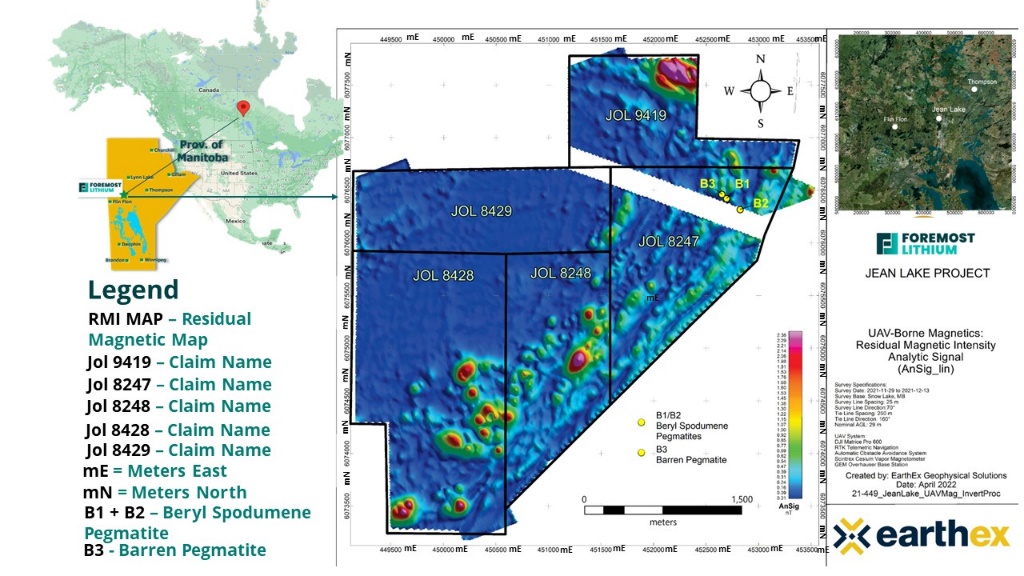
Fig 1. Drone Magnetic Survey Map of Jean Lake – different colors indicate magnetic highs and lows in the ground (the white gap in-between colors on map is powerline)
Jean Lake Property Highlights Include
- Power access through the property
- Year-round access
- Airstrip located 5 km to the northwest.
- Highway access within 11 km.
- Rail access 35 km to the south.
- Entrained within the Thompson Brothers Lithium Trend
EXPLORATION
Jean Lake remained unexplored for lithium since 1942 until Foremost Lithium began exploration efforts in the late summer of 2021. The Manitoba Mineral Development Fund ("MMDF") provided funding by way of a $300,000 grant, stimulating exploration on the property. The Beryl B1, B2 and B3 pegmatite dykes were re-discovered on the Jean Lake property in 2021 by prospecting beneath 80 years of organic and inorganic debris during this initial summer prospecting program.
Rock chip samples of spodumene-bearing mineralization were collected in August 2021 from blast material in two trenched locations of the Beryl pegmatites. Two of the samples were apple green, coarse grained spodumene and three samples were from straw-colored finer grained spodumene. Results of all samples returned high-grade lithium contents regardless of the textural characteristics of the spodumene. SGM-3, now referred to as the Beryl dyke or B1 returned assays of 3.89% and 5.17% Li2O and occurs to the south of Snow Lake Lithium’s high-grade Sherritt Gordon (SG) and Grass River (GRP) spodumene pegmatites. Rock chip samples were also collected for assay and returned assay results with maximum contents of 20.9 g/t gold. All but one sample exceeded 1 g/t gold.
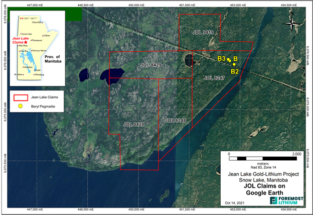
Figure 2 - Location of the Beryl Pegmatites B1, B2 and B3
Ongoing exploration, consisting of prospecting and geochemical surveys, continued in June 2022 utilizing the results from recently completed UAV-borne magnetic surveys. The UAV surveys were conducted between November 29, 2021, and December 20, 2021, and comprised 483.4-line km. The technology was utilized to aid in the definition of new prospective drill targets by producing high-resolution magnetic imagery, to define the 3D location, shape, size, and distribution of potential spodumene rich pegmatite dykes. The Company’s exploration efforts have focused on lithium in pegmatite using a variety of exploration technologies, which not only have exposed potential for spodumene, but which have also demonstrated the potential for gold mineralization.
DRILL PROGRAM
An inaugural drill program was announced on November 21, 2022, to test 14 high quality targets based on the integrated results of UAV-borne magnetic surveys, rock and soil geochemical surveys and outcrop prospecting. The drill program commenced December 2, 2022, and in June 2023, the results of the completed 3,002 meters diamond drill program were released. Assay results are based on a quality assurance and quality control program using industry best practices. Lithium and related elements are determined by ICP-MS after total sample dissolution and gold is determined by 30-gram assay and INAA finish. For assays above 5 g/t Au, a sub-sample of the original pulp is re-assayed with a gravimetric finish. Samples with visible gold are analyzed by metallic screen assay.
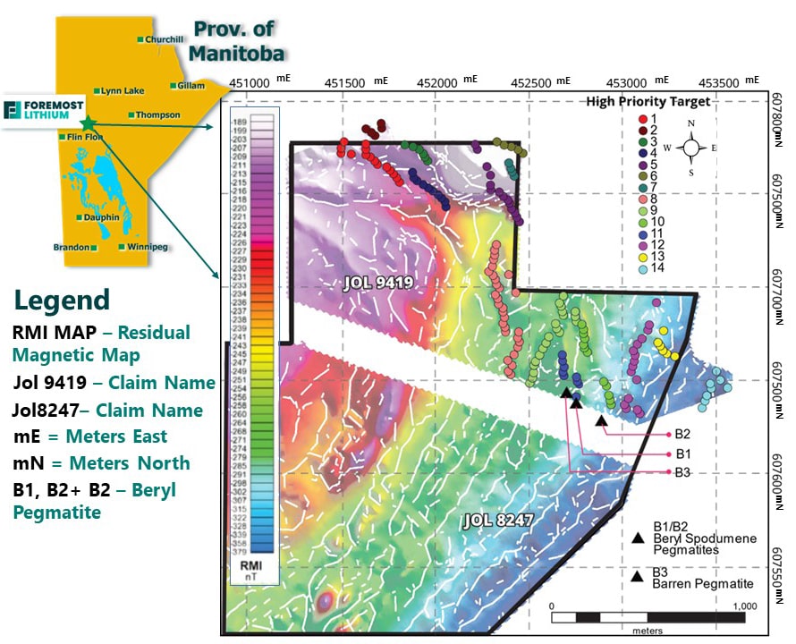
Figure 3. Map Display 14 High Priority Targets
RESULTS
Drill highlights include:
Lithium
- 1.26% Li2O over 3.35 metres in drill hole FM23-01A
Gold
- In drill hole FM23-8: 7.50 g/t Au over 7.66 metres from 94.35 - 102.01 m (including 102.0 g/t Au over 0.48 metres from 94.77 - 95.25 m)
- In drill hole FM23-04A: 11.27 g/t Au over 2.75 metres from 73.75 - 76.50 m (including 91.8 g/t Au over 0.32 metres from 74.74 - 75.06 m)
- In drill hole FM23-01A: 2.46 g/t Au over 3.70 metres from 41.30 - 45.00m
The Jean Lake drill program intersected numerous gold mineralized intervals at vertical depths up to 110 m below surface as well lithium at the B1 spodumene bearing pegmatite. The locations of drill holes that intersected gold mineralized intervals are illustrated in Figure 3, in addition to the B1 drill hole location. Details of the drilled gold and lithium intersections are provided in Table 1.
Table 1. Lithium and Gold Intersections from the 2022-2023 Drill Program.
| Hold ID | Easting | Northing | Strike | Dip | Depth | Intercepts in Meters |
| FM23-01A | 452688 | 6076420 | 205 | -66 | 62 | 1.26% Li2O over 0-3.35m |
| m | ||||||
| FM23-01A | 452688 | 6076420 | 205 | -66 | 62 | 2.46 g/t Au over 3.70m from 41.30m-45m |
| FM23-04A | 452743 | 6076529 | 90 | -45 | 80 | 11.27 g/t Au over 2.75m from 73.75m-76.5m including |
| 91.8 g/t Au over 0.32m from 74.74-75.06m | ||||||
| FM23-08 | 452877 | 6076534 | 245 | -45 | 134 | 1.44 g/t Au for 0.32m from 11.33m-11.65m |
| and | ||||||
| 7.50 g/t Au for 7.66m from 94.35m-102.01m including | ||||||
| 29.95 g/t Au for 1.77m from 94.35m-96.12m | ||||||
| and | ||||||
| 1.28 g/t Au for 0.3m from 107.6m-107.9m | ||||||
| FM23-08A | 452878 | 6076543 | 110 | -45 | 173 | 1.51 g/t Au for 0.52m from 95.18m-95.7m |
| FM23-13 | 452667 | 6076898 | 270 | -45 | 125 | 0.94g/t Au for 1.23m from 121.30m-122.53m |
| FM23-14 | 452732 | 6076854 | 270 | -45 | 158 | 1.23 g/t Au for 2.85m from 151.24-154.09m |
| FM23-22 | 450367 | 6073940 | 314 | -45 | 125 | 3.04 g/t Au for 0.68m from 102.92m-103.6m |
| FM23-25 | 452347 | 6076330 | 120 | -45 | 114 | 2.07 g/t Au for 3.49m from 25.3m-28.79m including |
| 6.86 g/t Au for 0.54m from 25.30m-25.84m | ||||||
| and | ||||||
| 1.27 g/t Au for 2.4m from 69.6m-72m | ||||||
Geology
Gold mineralization in the area occurs in association with finely disseminated to blocky arsenopyrite with lesser pyrite and chalcopyrite in quartz veins and adjacent silicified zones. The mineralization is developed within variably altered mafic to intermediate intrusive rocks of the Early Proterozoic Rex Lake Plutonic Complex (RLPC) that underpins the Jean Lake property. The B1 pegmatite is also hosted by the RLPC within structures trending at approximately 270o-290o. Of interest is the occurrence of 2.46 g/t Au over 3.70m from 41.30m-45m in FM23-01A. This intersection occurs in a shear zone at or near the base of the B1 pegmatite in fine grained gabbro. The gold is associated with quartz veins and arsenopyrite
HISTORY OF GOLD IN THE AREA
Historically, 5.5 million ounces of gold has been produced as a by-product of base metal copper-zinc massive sulphide type deposit production in addition to major gold deposits such as the New Britannia, Puffy Lake, and Tartan deposits, with cumulative production of more than 1.5 million ounces of gold in the Flin Flon-Snow Lake greenstone belt[1]. In 1940, two bulk samples of mineralization weighing 22.7 and 22.2 kg. respectively, were sent to the Canada Department of Mines and Resources in Ottawa for testing from what was known as the Sparky Gold Property at the time (the current Jean Lake Property)[2]. The first bulk sample contained 16.46 g/t gold and 2.39 g/t silver, and the second bulk sample contained 241.71 g/t gold and 12.34 g/t silver. Gold exploration continued unabated in the area with high-grade gold mineralization documented from numerous past producing gold mines and properties hosting significant gold mineralization.
Jean Lake Property – Gold History
In 1940, two bulk samples of mineralization weighing 22.7 and 22.2 kg. respectively, were sent to the Canada Department of Mines and Resources in Ottawa for testing from what was known as the Sparky Gold Property at the time (the current Jean Lake Property). The first bulk sample contained 16.46 g/t gold and 2.39 g/t silver, whereas the second bulk sample contained 241.71 g/t gold and 12.34 g/t silver. Gold exploration continued unabated in the area with high-grade gold mineralization documented from numerous past producing gold mines and properties hosting significant gold mineralization.
The proximity of these gold properties to our Jean Lake Property is illustrated in the map below in Figure 4, and Table 2 which summarizes historic gold and lithium abundances in the immediate area.
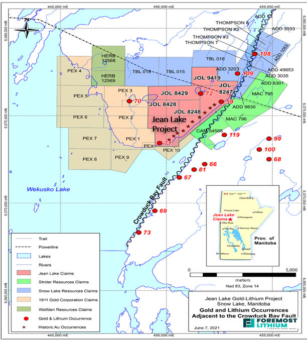
Figure 4. Jean Lake property and adjacent mineral properties with location of gold deposits and occurrences adjacent the Crowduck Bay Fault. The linear pattern of stars indicates the area of historic gold occurrences on the Jean Lake property.

Table 2. Summary of Historic Gold and Lthium Deposits with Corresponding Numbers on Adjacent Map
CURRENT GOLD PRODUCTION IN SNOW LAKE
Current gold production is ongoing in the Snow Lake area. In 2022 Hudbay Minerals Inc (current market cap of $C1.7Bill) re-opened the Lalor Mine in Snow Lake, MB, announcing that it estimates 33% of its overall revenue will now be generated from gold and silver, up significantly from 18% in 2019[3]. Hudbay Minerals’ current mineral reserve estimates in Snow Lake total 18 million tons with approximately 2.1 million ounces in contained gold, and the expected mine life of the Snow Lake operations to be maintained and extend until 2038. Hudbay’s annual gold production from Snow Lake is expected to average more than 190,000 ounces over the next three years.[4] The Flin Flon-Snow Lake belt is currently active with other mineral companies exploring for gold including QMX Gold Corporation, Kinross Gold, Callinex and Rockcliff Metals Corp.
CURRENT DEVELOPMENTS
A summer 2023 exploration program was undertaken from Dahrouge Exploration Consulting where Spodumene-pegmatite occurrences (B1, B2, and B3) that are collectively known as the “Beryl Pegmatites” were sampled and mapped in further detail. Four (4) chip samples were collected, three (3) of which were from spodumene bearing pegmatite, returning values of up to 1.86% Li2O. A drill program at Jean Lake is expected to follow up on the results from the last winter drill program with the hopes of expanding the high-grade spodumene occurrences at B1 and B2.
Assay highlights are presented in Table 2 below.
|
Sample ID |
Li (ppm) |
Li2O (%) |
Cs2O (ppm) |
Ta2O5 (ppm) |
|
153026 |
8434 |
1.82 |
24 |
1 |
|
153027 |
64 |
0.01 |
1 |
0 |
|
153029 |
8635 |
1.86 |
27 |
10 |
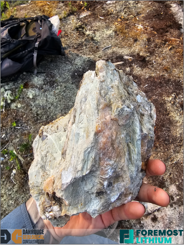
Photo 1 – Large spodumene crystals found in outcrop at the B1 pegmatite
QP STATEMENT
Lindsay Bottomer, P.Geo., is the Qualified Person (QP) responsible for reviewing and approving the technical material on the Jean Lake Property contained in this document. Mr Bottomer is a Qualified Person as defined by NI 43-101.